![A transport of Jewish prisoners marches through the snow from the Bauschovitz train station to Theresienstadt. [LCID: 69720]](https://encyclopedia.ushmm.org/images/large/781755a6-1ba5-4d8e-8b2b-9f25bdf3687f.jpg)
자료구분: 제목:
-
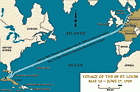
“세인트 루이스호”의 항해, 1939년 5월 13일-6월 17일
지도독일계 유태인 난민의 수난, 고국에서 박해 받고 원치 않는 해외 망명을 선택한 SS”세인트 루이스”호의 항해가 표현되어 있다. 1939년 5월 13일, 독일 여객선 SS “세인트 루이스”호는 거의 천여 명의 유태인 난민을 싣고 독일을 출발하였다. 난민들의 목적지는 쿠바였다. 그러나 그들이 도착하기도 전에 쿠바 정부는 그들의 하선 허가를 철회하였다. 그리하여 1939년 6월, “세인트…