![A transport of Jewish prisoners marches through the snow from the Bauschovitz train station to Theresienstadt. [LCID: 69720]](https://encyclopedia.ushmm.org/images/large/781755a6-1ba5-4d8e-8b2b-9f25bdf3687f.jpg)
ホロコーストと第二次世界大戦の間、またその前後の重要な場所を示した地図やテーマ別の地図をアルファベット順のリストで閲覧する。これらの地図は収容所、ゲットー、大量虐殺、そして軍事作戦、追放、侵攻といった様々な地理的な’動きを示しています。
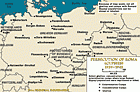
ロマ族(ジプシー)は、人種的な理由でナチス政権による迫害の対象に選ばれた集団の1つでした。 ロマ族は、抑留、移送、および強制労働の対象となり、絶滅収容所に送られました。 また、アインザッツグルッペン(移動虐殺部隊)は、ドイツ支配下の東部の領地で何万人ものロマ族を殺害しました。 ロマ族の運命はユダヤ人の運命と非常に似ていました。…
We would like to thank Crown Family Philanthropies, Abe and Ida Cooper Foundation, the Claims Conference, EVZ, and BMF for supporting the ongoing work to create content and resources for the Holocaust Encyclopedia. View the list of donor acknowledgement.