![A transport of Jewish prisoners marches through the snow from the Bauschovitz train station to Theresienstadt. [LCID: 69720]](https://encyclopedia.ushmm.org/images/large/781755a6-1ba5-4d8e-8b2b-9f25bdf3687f.jpg)
Browse an alphabetical list of geographic and thematic maps that depict important locations before, during, and after the Holocaust and World War II. These maps also show sites of camps, ghettos, and mass killings, and various geographical movements, such as military operations, deportations, or invasions.
<< Previous | Displaying results 1-18 of 18 for "Map" | Next >>


In July 1942, Anne Frank and her family went into hiding in Amsterdam until they were discovered and deported in 1944. View a map showing key locations.


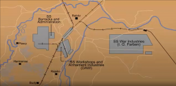
View an animated map showing key events in the history of the Auschwitz camp complex in German-occupied Poland.

Auschwitz was the largest camp established by the Germans. It was a complex of camps, including a concentration, extermination, and forced-labor camp. It was located at the town of Oswiecim near the prewar German-Polish border in Eastern Upper Silesia, an area annexed to Germany in 1939. Auschwitz I was the main camp and the first camp established at Oswiecim. Auschwitz II (Birkenau) was the killing center at Auschwitz. Trains arrived at Auschwitz-Birkenau almost daily with transports of Jews from…

Selected Features1. Camp Commandant's House2. Main Guard House3. Camp Administrative Office4. Gestapo5. Reception Building/Prisoner Registration6. Kitchen7. Gas Chamber and Crematorium8. Storage Buildings and Workshops9. Storage of Confiscated Belongings10. Gravel Pit: Execution Site11. Camp Orchestra Site12. "Black Wall" Execution Site13. Block 11: Punishment Bunker14. Block 10: Medical Experiments15. Gallows16. Block Commander's Barracks17. SS Hospital


We would like to thank Crown Family Philanthropies, Abe and Ida Cooper Foundation, the Claims Conference, EVZ, and BMF for supporting the ongoing work to create content and resources for the Holocaust Encyclopedia. View the list of donor acknowledgement.