![A transport of Jewish prisoners marches through the snow from the Bauschovitz train station to Theresienstadt. [LCID: 69720]](https://encyclopedia.ushmm.org/images/large/781755a6-1ba5-4d8e-8b2b-9f25bdf3687f.jpg)
Browse an alphabetical list of geographic and thematic maps that depict important locations before, during, and after the Holocaust and World War II. These maps also show sites of camps, ghettos, and mass killings, and various geographical movements, such as military operations, deportations, or invasions.
<< Previous | Displaying results 1-24 of 25 for "Map" | Next >>
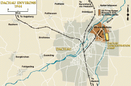
View an animated map showing key events in the history of the Dachau concentration camp, which was established by the Nazi regime in 1933.


Beginning in 1938, the Nazis increased their territorial control outside of Germany. By 1942, three years into World War II, Nazi Germany reached the peak of its expansion. At the height of its power, Germany had incorporated, seized, or occupied most of the continent. However, also in 1942, the Allied Powers started to systematically bomb Germany. They would continue to do so until Germany's surrender in 1945, weakening the war effort and demolishing cities.Slowly, the Allied Powers began pushing Germany…


We would like to thank Crown Family Philanthropies, Abe and Ida Cooper Foundation, the Claims Conference, EVZ, and BMF for supporting the ongoing work to create content and resources for the Holocaust Encyclopedia. View the list of donor acknowledgement.