![A transport of Jewish prisoners marches through the snow from the Bauschovitz train station to Theresienstadt. [LCID: 69720]](https://encyclopedia.ushmm.org/images/large/781755a6-1ba5-4d8e-8b2b-9f25bdf3687f.jpeg)
Browse an alphabetical list of geographic and thematic maps that depict important locations before, during, and after the Holocaust and World War II. These maps also show sites of camps, ghettos, and mass killings, and various geographical movements, such as military operations, deportations, or invasions.
<< Previous | Displaying results 1-25 of 398 for "Map" | Next >>
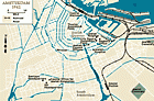
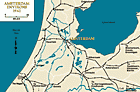
In July 1942, Anne Frank and her family went into hiding in Amsterdam until they were discovered and deported in 1944. View a map showing key locations.
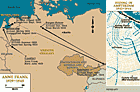
View an animated map showing key events in the history of the Auschwitz camp complex in German-occupied Poland.
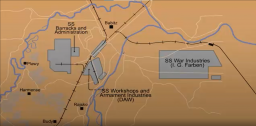
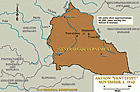
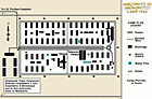
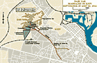
This map shows the Auschwitz camp complex in the summer of 1944.The SS established Auschwitz in spring 1940 as a concentration camp for Polish political prisoners. It was located in German-occupied Poland on the outskirts of the town of Oświęcim. Over the next several years, the camp was expanded and transformed into a sprawling camp complex. In March 1942, the SS began operating a killing center at Auschwitz where they murdered Jewish people from all over Europe. By 1944, the Auschwitz camp complex…
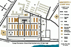
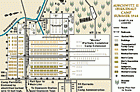
Selected Features1. Camp Commandant's House2. Main Guard House3. Camp Administrative Office4. Gestapo5. Reception Building/Prisoner Registration6. Kitchen7. Gas Chamber and Crematorium8. Storage Buildings and Workshops9. Storage of Confiscated Belongings10. Gravel Pit: Execution Site11. Camp Orchestra Site12. "Black Wall" Execution Site13. Block 11: Punishment Bunker14. Block 10: Medical Experiments15. Gallows16. Block Commander's Barracks17. SS Hospital
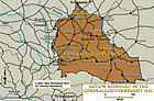
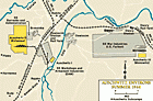
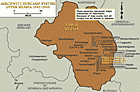
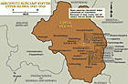
In October 1941, the Nazi authorities at Auschwitz began building a second camp located in the Polish village of Brzezinka (called Birkenau in German). Beginning in March 1942, Auschwitz-Birkenau functioned as both a concentration camp and a killing center, where the Nazis murdered Jews in gas chambers. From November 1943 to November 1944, Auschwitz-Birkenau was designated as a separate camp and officially referred to as Auschwitz II.
In late October 1942, the SS authorities at Auschwitz established a large subcamp that became known as Auschwitz-Monowitz. The SS established this subcamp to house Auschwitz prisoners assigned to forced labor at the I. G. Farben synthetic rubber and fuel plant. From November 1943 to November 1944, Auschwitz-Monowitz was designated as a separate camp and known as Auschwitz III. In November 1944, it became a separate concentration camp known as Monowitz. Prisoners sometimes called the camp “Buna.” Buna…
Between 1941 and 1944, the SS authorities at Auschwitz established almost 50 subordinate camps, also called subcamps. These subcamps varied in their design and purpose, but all supported the economic and ideological goals of the SS. At the subcamps, prisoners were forced to work in farming, animal husbandry, forestry, construction, and various industries (such as coal mining, armaments production, and chemical factories).

We would like to thank Crown Family Philanthropies, Abe and Ida Cooper Foundation, the Claims Conference, EVZ, and BMF for supporting the ongoing work to create content and resources for the Holocaust Encyclopedia. View the list of donor acknowledgement.